El r�o Ganges, en el subcontinente indio, es uno de los que m�s sedimentos transporta a los oc�anos del mundo. La erosi�n y la consiguiente carga de sedimentos son un peligro natural silencioso que puede afectar a los procesos hidr�ulicos de un sistema fluvial. La tasa de erosi�n f�sica en la cuenca del Alaknanda es cinco veces superior a la media mundial, y el r�o Alaknanda es uno de los principales suministradores de sedimentos al r�o Ganges. La morfolog�a fluvial podr�a aportar valiosos datos sobre ...
Read More
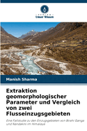
El r�o Ganges, en el subcontinente indio, es uno de los que m�s sedimentos transporta a los oc�anos del mundo. La erosi�n y la consiguiente carga de sedimentos son un peligro natural silencioso que puede afectar a los procesos hidr�ulicos de un sistema fluvial. La tasa de erosi�n f�sica en la cuenca del Alaknanda es cinco veces superior a la media mundial, y el r�o Alaknanda es uno de los principales suministradores de sedimentos al r�o Ganges. La morfolog�a fluvial podr�a aportar valiosos datos sobre las caracter�sticas hist�ricas de la deformaci�n tect�nica de la regi�n que se encuentra bajo �l. Diferentes �ndices geom�rficos como la Integral Hipsom�trica (Hi), el Coeficiente de Elongaci�n de la Cuenca (Eb), la Asimetr�a de la Cuenca de Drenaje (AF), el Perfil Longitudinal del R�o, el Perfil Transversal, el �ndice de Gradiente de la Corriente (SL) de la cuenca para desarrollar puntos de nudo en la cuenca. En este libro se investigaron los �ndices geom�rficos para caracterizar el patr�n del terreno y comparar la cuenca hidrogr�fica de los afluentes del r�o Alaknanda, a saber, Birahi Ganga y el r�o Nandakini.
Read Less