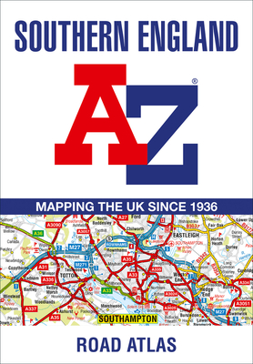
A full-colour regional road atlas featuring 39 pages of continuous road mapping. Covering an extensive area, including Bristol, Swindon, Reading, Slough, Guildford, Littlehampton, Portsmouth, Isle of Wight, Bournemouth, Cardiff, Newport, Weymouth, Sidmouth, Taunton and Weston-Super-Mare. This atlas is shown at a clear 2.5 miles to 1 inch scale (1.58 km to 1 cm) and includes the following features: Motorways open with full junction detail, motorways under construction and proposed, service areas, primary ...
Read More
A full-colour regional road atlas featuring 39 pages of continuous road mapping. Covering an extensive area, including Bristol, Swindon, Reading, Slough, Guildford, Littlehampton, Portsmouth, Isle of Wight, Bournemouth, Cardiff, Newport, Weymouth, Sidmouth, Taunton and Weston-Super-Mare. This atlas is shown at a clear 2.5 miles to 1 inch scale (1.58 km to 1 cm) and includes the following features: Motorways open with full junction detail, motorways under construction and proposed, service areas, primary routes and destinations, A & B roads, selected minor roads, gradients 1:5 and steeper, tolls, mileages, county boundaries, spot heights and hill shading Selected fuel stations National Park boundaries Selected places of interest, tourist information centres and golf courses Also included are 15 city, town, airport or port plans for: Bath, Bournemouth, Bristol, Cardiff, Guildford, Portsmouth, Reading, Salisbury, Southampton, Swindon, Taunton, Winchester, Windsor, London Heathrow Airport, and Poole Port. The expansive index section lists cities, towns, villages, hamlets and locations covered by this atlas.
Read Less
Add this copy of Southern England a-Z Road Atlas to cart. $7.20, new condition, Sold by Ria Christie Books rated 5.0 out of 5 stars, ships from Uxbridge, MIDDLESEX, UNITED KINGDOM, published 2023 by HarperCollins.
Add this copy of Southern England A-Z Road Atlas to cart. $7.32, new condition, Sold by Ria Christie Books rated 5.0 out of 5 stars, ships from Uxbridge, MIDDLESEX, UNITED KINGDOM, published 2023 by HarperCollins.
Add this copy of Southern England a-Z Road Atlas to cart. $9.04, new condition, Sold by Books2anywhere rated 5.0 out of 5 stars, ships from Fairford, GLOUCESTERSHIRE, UNITED KINGDOM, published 2023 by HarperCollins Publishers.
Choose your shipping method in Checkout. Costs may vary based on destination.
Seller's Description:
PLEASE NOTE, WE DO NOT SHIP TO DENMARK. New Book. Shipped from UK in 4 to 14 days. Established seller since 2000. Please note we cannot offer an expedited shipping service from the UK.
Add this copy of Southern England a-Z Road Atlas to cart. $9.23, new condition, Sold by Kennys.ie rated 4.0 out of 5 stars, ships from Galway, IRELAND, published 2023 by HarperCollins.
Add this copy of Southern England A-Z Road Atlas to cart. $9.18, new condition, Sold by Booksplease rated 3.0 out of 5 stars, ships from Southport, MERSEYSIDE, UNITED KINGDOM, published 2023 by HarperCollins.
Add this copy of Southern England a-Z Road Atlas to cart. $9.61, new condition, Sold by Paperbackshop International rated 2.0 out of 5 stars, ships from Fairford, GLOS, UNITED KINGDOM, published 2023 by HarperCollins Publishers.
Choose your shipping method in Checkout. Costs may vary based on destination.
Seller's Description:
PLEASE NOTE, WE DO NOT SHIP TO DENMARK. New Book. Shipped from UK in 4 to 14 days. Established seller since 2000. Please note we cannot offer an expedited shipping service from the UK.
Add this copy of Southern England a-Z Road Atlas to cart. $18.54, new condition, Sold by Paperbackshop rated 4.0 out of 5 stars, ships from Bensenville, IL, UNITED STATES, published 2023 by HarperCollins Publishers.
Add this copy of Southern England Regional a-Z Road Atlas to cart. $53.97, new condition, Sold by BetterBookDeals rated 4.0 out of 5 stars, ships from Toronto, ON, CANADA, published 2023 by Geographers' A-Z Map Co Ltd.
Add this copy of Southern England Regional a-Z Road Atlas to cart. $64.96, new condition, Sold by Bonita rated 4.0 out of 5 stars, ships from Newport Coast, CA, UNITED STATES, published 2023 by Geographers? A-Z Map Co Ltd.