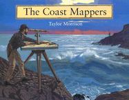
In the mid-nineteenth century, little was known of the west coast and waterways. The ships that sailed those waters did so at a considerable risk, sometimes depending on only a school atlas to navigate and all too often crashing into the rocks. So the U.S. Coast Survey, whose purpose was to map every mile of American shoreline, commissioned George Davidson to chart all of the major points on the coast and all of the waterways in between. In this beautifully illustrated book, Taylor Morrison chronicles the challenges and ...
Read More
In the mid-nineteenth century, little was known of the west coast and waterways. The ships that sailed those waters did so at a considerable risk, sometimes depending on only a school atlas to navigate and all too often crashing into the rocks. So the U.S. Coast Survey, whose purpose was to map every mile of American shoreline, commissioned George Davidson to chart all of the major points on the coast and all of the waterways in between. In this beautifully illustrated book, Taylor Morrison chronicles the challenges and adventures Davidson and his team faced and the methods they used to accomplish this monumental, and essential, task.
Read Less
Choose your shipping method in Checkout. Costs may vary based on destination.
Seller's Description:
Near Fine in Very Good + jacket. Size: 10x0x8; Clean, solid copy with unmarked text. Cover corners are square, binding is firm. Jacket is glossy with light surface and edge wear; a little age toning and wrinkling along top back edge. No tears. A very nice copy overall. 1st printing. Books, box sets, and items other than standard jewel case CDs and DVDs that sell for $9 or more ship in a box; under $9 in a bubble mailer. Expedited and international orders may ship in a flat rate envelope rather than a box due to cost constraints. All US-addressed items ship with complimentary delivery confirmation.