As miniature worlds, beautiful locations and homes to communities seemingly distant from the stresses of modern life, Scotland's many islands have an extraordinary fascination on countless people, not least on the hundreds of thousands of visitors who visit them each year. Maps too fascinate, as objects of visual delight and historical importance, and as a means to represent and understand landscapes. This stimulating and informative book reproduces some of the most beautiful and historically significant maps from the ...
Read More
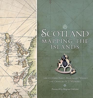
As miniature worlds, beautiful locations and homes to communities seemingly distant from the stresses of modern life, Scotland's many islands have an extraordinary fascination on countless people, not least on the hundreds of thousands of visitors who visit them each year. Maps too fascinate, as objects of visual delight and historical importance, and as a means to represent and understand landscapes. This stimulating and informative book reproduces some of the most beautiful and historically significant maps from the National Library of Scotland's magnificent collection in order to explore the many dimensions of island life and how this has changed over time. Arranged thematically and covering topics such as population, place-names, defence, civic improvement, natural resources, navigation, and leisure and tourism, Scotland: Mapping the Islands presents the rich and diverse story of Scottish islands from the earliest maps to the most up-to date techniques of digital mapping in a unique and imaginative way.
Read Less
Choose your shipping method in Checkout. Costs may vary based on destination.
Seller's Description:
Very good. All orders ship SAME or NEXT business day. Expedited shipments will be received in 1-5 business days within the United States. We proudly ship to APO/FPO addresses. 100% Satisfaction Guaranteed!