Rand McNally's Easy To Read State Folded Map is a must-have for anyone traveling in and around Michigan, offering unbeatable accuracy and reliability at a great price. Our trusted cartography shows all Interstate, U.S., state, and county highways, along with clearly indicated parks, points of interest, airports, county boundaries, and streets. The easy-to-use legend and detailed index make for quick and easy location of destinations. You'll see why Rand McNally folded maps have been the trusted standard for years. - ...
Read More
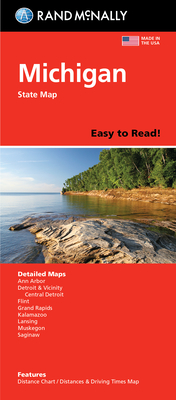
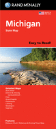
Rand McNally's Easy To Read State Folded Map is a must-have for anyone traveling in and around Michigan, offering unbeatable accuracy and reliability at a great price. Our trusted cartography shows all Interstate, U.S., state, and county highways, along with clearly indicated parks, points of interest, airports, county boundaries, and streets. The easy-to-use legend and detailed index make for quick and easy location of destinations. You'll see why Rand McNally folded maps have been the trusted standard for years. - Regularly updated, full-color maps. - 45% larger map with a bigger type size than the Rand McNally Folded Map. -Clearly labeled Interstate, U.S., state, and county highways. -Indications of parks, points of interest, airports, county boundaries, and more. -Mileage and driving times map. - Detailed index. -Convenient folded size. Coverage Area: Detailed maps of: Ann Arbor, Detroit & Vicinity, Downtown Detroit, Flint, Grand Rapids, Kalamazoo, Lansing, Muskegon, Saginaw. Product Details: Dimensions (unfolded): 28 x 40.
Read Less
Choose your shipping method in Checkout. Costs may vary based on destination.
Seller's Description:
New. Brand New! Not Overstocks or Low Quality Book Club Editions! Direct From the Publisher! We're a small town bookstore that loves books and loves it's customers! Buy from US! Glued binding.