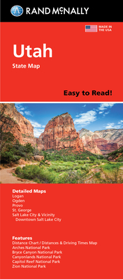
Rand McNally's folded map for Utah is a must-have for anyone traveling in or through the state, offering unbeatable accuracy and reliability at a great price. Our trusted cartography shows all Interstate, U.S., state, and county highways and much more. - Points of interest. - State park chart. - State mileage chart. - Driving times map. - On-the-road toolbox. - Visitor center information. - Climate data. - State facts & symbols. - Easy-to-use legend. - Detailed indexed. Coverage Area: Detailed maps include, Arches National ...
Read More
Rand McNally's folded map for Utah is a must-have for anyone traveling in or through the state, offering unbeatable accuracy and reliability at a great price. Our trusted cartography shows all Interstate, U.S., state, and county highways and much more. - Points of interest. - State park chart. - State mileage chart. - Driving times map. - On-the-road toolbox. - Visitor center information. - Climate data. - State facts & symbols. - Easy-to-use legend. - Detailed indexed. Coverage Area: Detailed maps include, Arches National Park, Bryce Canyon National Park, Canyonlands National Park, Capitol Reef National Park, Logan, Ogden, Provo, St. George, Salt Lake City & Vicinity, Salt Lake City Downtown, Zion National Park. Product Details: Measures 9.0 x 4.125 and folds out to 25.5 x 36.75.
Read Less
Choose your shipping method in Checkout. Costs may vary based on destination.
Seller's Description:
New. Brand New! Not Overstocks or Low Quality Book Club Editions! Direct From the Publisher! We're a small town bookstore that loves books and loves it's customers! Buy from US! Glued binding.