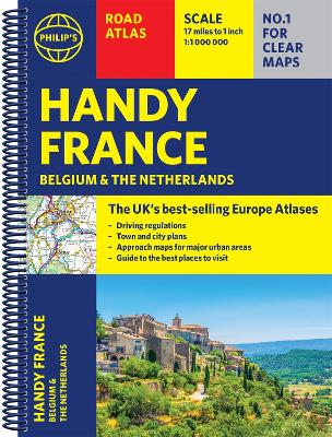
Philip's Handy Road Atlas of France, Belgium and The Netherlands features new digital cartography voted Britain's clearest and most detailed European mapping in an independent consumer survey. This glove-box size, compact A5 atlas with lie-flat binding is perfect for travelling across France and the surrounding countries. Philip's Road Atlas France, Belgium and The Netherlands shows the national road networks at a scale of 1:1 million, with ultra-clear, detailed mapping for urban areas. All the scenic routes are clearly ...
Read More
Philip's Handy Road Atlas of France, Belgium and The Netherlands features new digital cartography voted Britain's clearest and most detailed European mapping in an independent consumer survey. This glove-box size, compact A5 atlas with lie-flat binding is perfect for travelling across France and the surrounding countries. Philip's Road Atlas France, Belgium and The Netherlands shows the national road networks at a scale of 1:1 million, with ultra-clear, detailed mapping for urban areas. All the scenic routes are clearly highlighted, and the maps show huge numbers of places to visit including beaches, theme parks, national parks and World Heritage Sites. Alongside the easy-to-read, bestselling mapping is: * Special route-planner spread * Listings for ski resorts and top visitor attractions; * Summary of driving regulations in France, Belgium and the Netherlands * Pages of clear, detailed road maps, with car ferries and toll, toll-free and pre-pay motorways all clearly marked * Large-scale approach maps for four major cities (Bordeaux, Lyon, Paris, Strasbourg) to avoid jams * City-centre plans marking historic buildings and tourist attractions as well as car parks, head post offices and other facilities in eight major cities (Amsterdam, Brussels, Bordeaux, Luxembourg, Lyon, Marseilles, Paris, Strasbourg).
Read Less
Choose your shipping method in Checkout. Costs may vary based on destination.
Seller's Description:
Fine. Philip's Road Atlases . In Stock. 100% Money Back Guarantee. Brand New, Perfect Condition, allow 4-14 business days for standard shipping. To Alaska, Hawaii, U.S. protectorate, P.O. box, and APO/FPO addresses allow 4-28 business days for Standard shipping. No expedited shipping. All orders placed with expedited shipping will be cancelled. Over 3, 000, 000 happy customers.
Choose your shipping method in Checkout. Costs may vary based on destination.
Seller's Description:
Good. Simply Brit welcome to our online used book store, where affordability meets great quality. Dive into a world of captivating reads without breaking the bank. We take pride in offering a wide selection of used books, from classics to hidden gems, ensuring there's something for every literary palate. All orders are shipped within 24 hours and our lightning fast-delivery within 48 hours coupled with our prompt customer service ensures a smooth journey from ordering to delivery. Discover the joy of reading with us, your trusted source for affordable books that do not compromise on quality.
Choose your shipping method in Checkout. Costs may vary based on destination.
Seller's Description:
Good. **SHIPPED FROM UK** We believe you will be completely satisfied with our quick and reliable service. All orders are dispatched as swiftly as possible! Buy with confidence! Greener Books.
Choose your shipping method in Checkout. Costs may vary based on destination.
Seller's Description:
PLEASE NOTE, WE DO NOT SHIP TO DENMARK. New Book. Shipped from UK in 4 to 14 days. Established seller since 2000. Please note we cannot offer an expedited shipping service from the UK.
Choose your shipping method in Checkout. Costs may vary based on destination.
Seller's Description:
PLEASE NOTE, WE DO NOT SHIP TO DENMARK. New Book. Shipped from UK in 4 to 14 days. Established seller since 2000. Please note we cannot offer an expedited shipping service from the UK.