Philip's Complete Road Atlas Europe 2011 gives more for leisure travellers than any comparable product. In addition to the main maps at 1:750,000, the continental road network is shown at three supplementary scales from 1:250,000 to 1:3M, with ultra-clear detailed maps for urban areas. Scenic routes are highlighted on the road maps, with theme parks and World Heritage sites clearly shown. The maps also highlight towns with low emission zones and show motorway rest/parking areas. In addition, Philip's Complete Road Atlas ...
Read More
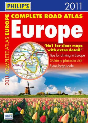
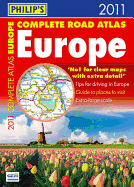
Philip's Complete Road Atlas Europe 2011 gives more for leisure travellers than any comparable product. In addition to the main maps at 1:750,000, the continental road network is shown at three supplementary scales from 1:250,000 to 1:3M, with ultra-clear detailed maps for urban areas. Scenic routes are highlighted on the road maps, with theme parks and World Heritage sites clearly shown. The maps also highlight towns with low emission zones and show motorway rest/parking areas. In addition, Philip's Complete Road Atlas Europe 2011 features a unique fact-finder that provides key statistics, currency information and recent events for each country. Philip's Complete Road Atlas Europe 2011 includes: Up-to-date driving regulations, including speed limits, for every country in Europe; Listings for ski resorts and top visitor attractions, country by country; 22 pages of route-planning maps which enable journeys of over 800 miles to be planned without turning a page; 175 pages of clear, detailed road maps, with scenic routes highlighted and toll, toll-free and pre-pay motorways all clearly marked; Large-scale approach maps for 31 major cities; 50 city-centre plans marking historic buildings and tourist attractions, as well as car parks, head post offices and other facilities.
Read Less
Add this copy of Philip's Complete Road Atlas Europe 2011 to cart. $64.49, good condition, Sold by Bonita rated 4.0 out of 5 stars, ships from Newport Coast, CA, UNITED STATES, published 2010 by Philip's.