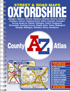
This county atlas of Oxfordshire has 136 pages of coloured street mapping that feature all the major towns and villages. Also included are 10 pages of road mapping covering the whole county. The street mapping includes coverage of: *Abingdon, Banbury, Bicester, Blewbury, Bloxham, Burford, Carterton, Charlbury, Chinnor, Chipping Norton, Didcot, Eynsham, Faringdon, Goring, Henley-on-Thames, Kidlington, Oxford, Pangbourne, Shrivenham, Sonning Common, Steeple Aston, Thame, Wallingford, Wantage, Watlington, Wheatley, ...
Read More
This county atlas of Oxfordshire has 136 pages of coloured street mapping that feature all the major towns and villages. Also included are 10 pages of road mapping covering the whole county. The street mapping includes coverage of: *Abingdon, Banbury, Bicester, Blewbury, Bloxham, Burford, Carterton, Charlbury, Chinnor, Chipping Norton, Didcot, Eynsham, Faringdon, Goring, Henley-on-Thames, Kidlington, Oxford, Pangbourne, Shrivenham, Sonning Common, Steeple Aston, Thame, Wallingford, Wantage, Watlington, Wheatley, Witney and Woodstock. *Also included is a large scale city centre map of Oxford. Postcode districts and one-way streets are featured on the street mapping. The index section lists streets, selected flats, walkways and places of interest, place, area and station names. There are separate lists of the Oxford University Colleges and Halls and of hospitals and hospices covered by this atlas.
Read Less
Choose your shipping method in Checkout. Costs may vary based on destination.
Seller's Description:
Very good. **SHIPPED FROM UK** We believe you will be completely satisfied with our quick and reliable service. All orders are dispatched as swiftly as possible! Buy with confidence! Greener Books.