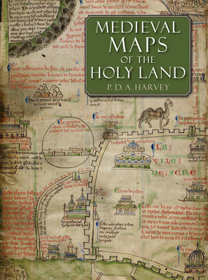
Neglected since the 1890s, the eight medieval regional maps of the Holy Land that are known to have existed are interesting, picturesque and mostly colourful. Many of the surviving copies and fragments are reproduced here for the first time, including three large maps that are among medieval Europe's finest cartographic monuments. Painstaking detective work on the manuscripts reveals much that is new: two maps lurking behind others drawn over them, a map changed into an erotic fantasy by a nineteenth-century forger, the ...
Read More
Neglected since the 1890s, the eight medieval regional maps of the Holy Land that are known to have existed are interesting, picturesque and mostly colourful. Many of the surviving copies and fragments are reproduced here for the first time, including three large maps that are among medieval Europe's finest cartographic monuments. Painstaking detective work on the manuscripts reveals much that is new: two maps lurking behind others drawn over them, a map changed into an erotic fantasy by a nineteenth-century forger, the origin of the mysterious grid pattern on some of the maps and much else. This beautifully produced large-format book is an important contribution to our understanding of medieval culture, early mapping and crusading Europe.
Read Less
Publisher:
The British Library Publishing Division
Published:
2012
Language:
English
Alibris ID:
17928858252
Shipping Options:
Standard Shipping: $4.67
Choose your shipping method in Checkout. Costs may vary based on destination.
Seller's Description:
This item is in overall good condition. Covers and dust jackets are intact but may have minor wear including slight curls or bends to corners as well as cosmetic blemishes including stickers. Pages are intact but may have minor highlighting/ writing. Binding is intact; however, spine may have slight wear overall. Minor shelf wear overall. Please note that all items are donated goods and are in used condition. Orders shipped Monday through Friday! Your purchase helps put people to work and learn life skills to reach their full potential. Orders shipped Monday through Friday. Your purchase helps put people to work and learn life skills to reach their full potential. Thank you!
Publisher:
The British Library Publishing Division
Published:
2012
Language:
English
Alibris ID:
15791068763
Shipping Options:
Standard Shipping: $4.67
Choose your shipping method in Checkout. Costs may vary based on destination.
Seller's Description:
New. 0712358242. *** FREE UPGRADE to Courier/Priority Shipping Upon Request ***-*** IN STOCK AND IMMEDIATELY AVAILABLE FOR SHIPMENT-Flawless copy, brand new, pristine, never opened--182 pages; illustrated with black and white and a number of color images. --with a bonus offer--
Publisher:
The British Library Publishing Division
Published:
2012
Language:
English
Alibris ID:
17736727251
Shipping Options:
Standard Shipping: $4.67
Choose your shipping method in Checkout. Costs may vary based on destination.
Seller's Description:
New in New jacket. Book. Folio. London: British Library, 2012. First edition. Folio. Hard cover binding, 160 pp. Illustrated throughout in color. This study examines the eight known medieval regional maps of the Holy Land. Interesting, picturesque, and often colorful, these maps provide great insight into how the Holy Land was perceived by Western Europe in the age of the Crusades. Many of the surviving copies and fragments from the period are reproduced here for the first time, including three large maps that are among medieval Europe's finest cartographic monuments. In the course of this study P. D. A. Harvey, a leading historian of medieval maps, undertook detailed detective work that revealed many new discoveries, such as two maps hidden behind newer renditions, a map that was transformed into an erotic fantasy by a nineteenth-century forger, and information about the origin of a mysterious grid pattern on some of the maps. The research and illustrations presented in Medieval Maps of the Holy Land constitute an important contribution to the studies of medieval culture, early mapping, and crusading Europe. New in new dust jacket, protected with an archival-quality mylar cover.