Map-Pack of the John Muir Trail: 13 Six-Color, Shaded-Relief Topographic Maps of the John Muir and Pacific Crest Trails Between MT Whitney and Yosemite Valley
Map-Pack of the John Muir Trail: 13 Six-Color, Shaded-Relief Topographic Maps of the John Muir and Pacific Crest Trails Between MT Whitney and Yosemite Valley
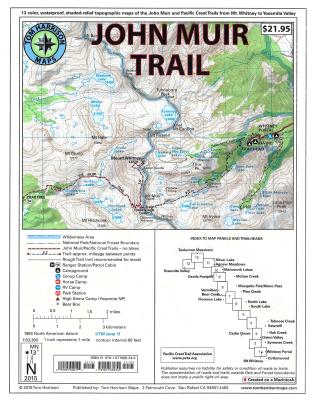
Shaded Relief Topo Maps packet of the famous Sierra High Route that will take hikers from Mount Whitney to Yosemite, CA. Well marked trails over USGS topo maps that were beautifully enhanced with shaded relief to better distinguish details. Scale 1:630360. 1 inch on map equals 1 mile. Whitney Portal, Symmes Creek, Onion Valley, Oak Creek, Taboose Creek, North and South Lakes, Vermilion, Bear Creek, Florence Lake, Pine Creek, Mono Pass, McGee Creek, Devils Postpile, Mammoth Lakes, Agnew Meadows, Silver Lake, Tuolomne Meadows ...
Read More
Shaded Relief Topo Maps packet of the famous Sierra High Route that will take hikers from Mount Whitney to Yosemite, CA. Well marked trails over USGS topo maps that were beautifully enhanced with shaded relief to better distinguish details. Scale 1:630360. 1 inch on map equals 1 mile. Whitney Portal, Symmes Creek, Onion Valley, Oak Creek, Taboose Creek, North and South Lakes, Vermilion, Bear Creek, Florence Lake, Pine Creek, Mono Pass, McGee Creek, Devils Postpile, Mammoth Lakes, Agnew Meadows, Silver Lake, Tuolomne Meadows, and finally the Yosemite Valley. GPS Compatible! - Complete UTM Grid. Printed on waterproof & tear resistant plastic.
Read Less
Choose your shipping method in Checkout. Costs may vary based on destination.
Seller's Description:
New. Brand New! Not Overstocks or Low Quality Book Club Editions! Direct From the Publisher! We're a small town bookstore that loves books and loves it's customers! Buy from US! 14 p. Contains: Illustrations.