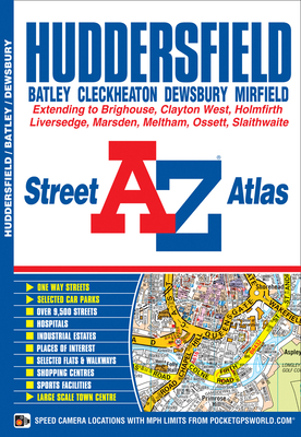
This atlas of Huddersfield features 65 pages of coloured street mapping and covers an area extending to Cleckheaton, Birstall, Batley, Gawthorpe, Ossett, Thornhill, Emley, Clayton West, Skelmanthorpe, Denby Dale, Scholes, Holmfirth, Netherthong, Meltham, Marsden, Slaithwaite, Stainland, Southowram, Brighouse and Hightown. Also included is a large scale town centre plan of Huddersfield. Post code districts are featured on the street mapping. The index section lists streets, selected flats, walkways and places of ...
Read More
This atlas of Huddersfield features 65 pages of coloured street mapping and covers an area extending to Cleckheaton, Birstall, Batley, Gawthorpe, Ossett, Thornhill, Emley, Clayton West, Skelmanthorpe, Denby Dale, Scholes, Holmfirth, Netherthong, Meltham, Marsden, Slaithwaite, Stainland, Southowram, Brighouse and Hightown. Also included is a large scale town centre plan of Huddersfield. Post code districts are featured on the street mapping. The index section lists streets, selected flats, walkways and places of interest, place, area and National Rail station names, hospitals and hospices covered by this atlas.
Read Less
Choose your shipping method in Checkout. Costs may vary based on destination.
Seller's Description:
Very good. Simply Brit welcome to our online used book store, where affordability meets great quality. Dive into a world of captivating reads without breaking the bank. We take pride in offering a wide selection of used books, from classics to hidden gems, ensuring there's something for every literary palate. All orders are shipped within 24 hours and our lightning fast-delivery within 48 hours coupled with our prompt customer service ensures a smooth journey from ordering to delivery. Discover the joy of reading with us, your trusted source for affordable books that do not compromise on quality.