First published in 1987. The cartographic history of Hawaii began with the arrival of explorer and chartmaker Captain James Cook in 1778. Between then and the mid-19th century, visitors to Hawaii produced a rich assortment of charts amid maps depicting the shores, harbors, towns, and volcanoes of the various islands. This volume traces the story of the mapping of Hawaii during the pivotal years in which the indigenous society was radically transformed by the peoples and ideas imported from the West. A major segment of The ...
Read More
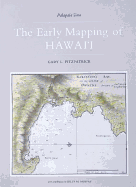
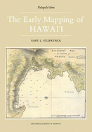
First published in 1987. The cartographic history of Hawaii began with the arrival of explorer and chartmaker Captain James Cook in 1778. Between then and the mid-19th century, visitors to Hawaii produced a rich assortment of charts amid maps depicting the shores, harbors, towns, and volcanoes of the various islands. This volume traces the story of the mapping of Hawaii during the pivotal years in which the indigenous society was radically transformed by the peoples and ideas imported from the West. A major segment of The Early Mapping of Hawaii it examines the contribution of American missionaries in mapping Hawaii. Mostly produced at the seminary school at Lahainaluna, Maui, these maps introduced geographical education into the Hawaiian school system. Lahainaluna graduate S. P. Kalama produced a landmark map of the islands in 1838, one of the most significant maps in Hawaiian history. Nearly one hundred maps, views, portraits, and illustrations are reproduced here. Included are many charts and harbor plans produced by James Cook, William Bligh, George Vancouver, Otto von Kotzebue, Urey Lisiansky, Jean Francois de la P???rouse, Louis Duperrey, and Charles Wilkes. These charts document the early geography of Honolulu, Lahaina, Hilo, and Kailua, as well as many bays and harbors in the islands.
Read Less
Choose your shipping method in Checkout. Costs may vary based on destination.
Seller's Description:
Very Good+ Very Good Dust Jacket. Size: 10x1x14; Honolulu: Editions Limited, 1986. 1st printing/1st edition. Interior appears free of markings. Binding is tight, sturdy, and square. Boards in great shape. Dust jacket has light sunning, rubbing, minor edgewear. NOT ex-library. A very good+ hardcover with very good-dust jacket. Ships same or next business day from Dinkytown in Minneapolis, Minnesota. Not available for priority/expedited shipping. Due to the size/weight of this book extra charges may apply for international shipping.
Choose your shipping method in Checkout. Costs may vary based on destination.
Seller's Description:
Fine in Near Fine jacket. Book. Folio-over 12-15" tall. 160 pp, preface, acknowldegments, 7 chapters, notes, citations of 90 numbered illustrations, Bibliography, index. Binding tight and sqauare, glossy pages unmarked, clean, cover cloth and letters crisp-Fine, 10.4" x 14.5" textured off-white cloth covered boards, with brown letters to fr and spine, in pale gray DJ. Unclipped in protector.
Choose your shipping method in Checkout. Costs may vary based on destination.
Seller's Description:
Fine in Near Fine jacket. Folio-over 12"-15" tall. 160pp/illus/maps. The story of the mapping of Hawaii from its discovery in 1778 by CaptainJames Cook and the influence of the West. Clean.
Choose your shipping method in Checkout. Costs may vary based on destination.
Seller's Description:
Very Good in a Very Good dust jacket; Hardcover; Dust jacket is clean and intact with no tears, and has not been price-clipped (Now fitted with a new, Brodart jacket protector); Light wear to the boards; The textblock edges are unblemished; The endpapers and all text pages are clean and unmarked; The binding is excellent with a straight spine; This book will be shipped in a sturdy cardboard box with foam padding; Extra-Large Format (Folio, 14"-16" tall); 3.5 lbs; Beige dust jacket with map illustration, and title in white lettering; 1987, Routledge Publishing; 160 pages; "The Early Mapping Of Hawaii (Palapala-aina), " by Gary L. Fitzpatrick.
Choose your shipping method in Checkout. Costs may vary based on destination.
Seller's Description:
PLEASE NOTE, WE DO NOT SHIP TO DENMARK. New Book. Shipped from UK in 4 to 14 days. Established seller since 2000. Please note we cannot offer an expedited shipping service from the UK.
Choose your shipping method in Checkout. Costs may vary based on destination.
Seller's Description:
PLEASE NOTE, WE DO NOT SHIP TO DENMARK. New Book. Shipped from UK in 4 to 14 days. Established seller since 2000. Please note we cannot offer an expedited shipping service from the UK.