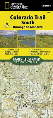
- Waterproof - Tear-Resistant - Topographic Map The Colorado Trail, South Topographic Map Guide has been designed as the perfect traveling companion when navigating the southern section of The Colorado Trail. In a state known for its trails, The Colorado Trail is Colorado's premier long distance trail. Conceived in 1973 and completed in 1987, the trail runs 486 miles between Denver and Durango, traversing some of the most spectacular scenery in the state. When The Colorado Trail is traversed from its southern ...
Read More
- Waterproof - Tear-Resistant - Topographic Map The Colorado Trail, South Topographic Map Guide has been designed as the perfect traveling companion when navigating the southern section of The Colorado Trail. In a state known for its trails, The Colorado Trail is Colorado's premier long distance trail. Conceived in 1973 and completed in 1987, the trail runs 486 miles between Denver and Durango, traversing some of the most spectacular scenery in the state. When The Colorado Trail is traversed from its southern terminus outside of Durango it climbs steeply into the San Juan Mountains where it stays above 10,000 feet for almost 150 miles with only a single steep decent to the Animas River near Silverton. The highest point on the trail is found in the San Juan Mountains at 13,271 feet. After leaving the San Juan Mountains, the trail travels for a short time below 10,000 feet before once again climbing into the Sawatch Range and joining The Colorado Trail North and Collegiate Loop. Each page is centered on the trail and overlaps with adjacent pages so there is little chance of getting lost. Along the bottom of each page is a trail profile that shows the distance between passes, camping areas, and trail access points. The map and trail profile provide a step by step visual guide to hiking the trail, mile by rugged mile. Expertly researched and created in partnership with local land management agencies including The Colorado Trail Foundation, this map guide provides detailed topographic maps, interesting history, bike detour maps, and a resupply location chart shows distances, and services available at each resupply point. More convenient and easier to use than folded maps, but just as compact and lightweight, National Geographic's Topographic Map Guide booklets are printed on "Backcountry Tough" waterproof, tear-resistant paper with stainless steel staples. A full UTM grid is printed on the map to aid with GPS navigation. Map Scale = 1:75,000 Folded Size = 4.25" x 9.38"
Read Less
Choose your shipping method in Checkout. Costs may vary based on destination.
Seller's Description:
PLEASE NOTE, WE DO NOT SHIP TO DENMARK. New Book. Shipped from UK in 4 to 14 days. Established seller since 2000. Please note we cannot offer an expedited shipping service from the UK.
Choose your shipping method in Checkout. Costs may vary based on destination.
Seller's Description:
PLEASE NOTE, WE DO NOT SHIP TO DENMARK. New Book. Shipped from UK in 4 to 14 days. Established seller since 2000. Please note we cannot offer an expedited shipping service from the UK.
Choose your shipping method in Checkout. Costs may vary based on destination.
Seller's Description:
This item is in overall good condition. Covers and dust jackets are intact but may have minor wear including slight curls or bends to corners as well as cosmetic blemishes including stickers. Pages are intact but may have minor highlighting/ writing. Binding is intact; however, spine may have slight wear overall. Digital codes may not be included and have not been tested to be redeemable and/or active. Minor shelf wear overall. Please note that all items are donated goods and are in used condition. Orders shipped Monday through Friday! Your purchase helps put people to work and learn life skills to reach their full potential. Orders shipped Monday through Friday. Your purchase helps put people to work and learn life skills to reach their full potential. Thank you!


![Appalachian Trail, Bailey Gap to Calf Mountain [virginia]](https://www0.alibris-static.com/appalachian-trail-bailey-gap-to-calf-mountain-virginia/isbn/9781597756419.gif)
![Appalachian Trail, Springer Mountain to Davenport Gap [georgia, North Carolina, Tennessee]](https://www2.alibris-static.com/appalachian-trail-springer-mountain-to-davenport-gap-georgia-north-carolina-tennessee/isbn/9781597756389.gif)
![Appalachian Trail, Davenport Gap to Damascus [north Carolina, Tennessee]](https://www0.alibris-static.com/appalachian-trail-davenport-gap-to-damascus-north-carolina-tennessee/isbn/9781597756396.gif)


