From its conversion to Christianity to the Genocide during World War I, from the Soviet occupation to its recent independence, Armenia has seen a long and often turbulent history. In the magnificent Armenia: A Historical Atlas, Robert H. Hewsen traces Armenia's rich past from ancient times to the present day through more than two hundred full-color maps packed with information about physical geography, demography, and sociopolitical, religious, cultural, and linguistic history. Hewsen has divided the maps into five ...
Read More
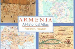
From its conversion to Christianity to the Genocide during World War I, from the Soviet occupation to its recent independence, Armenia has seen a long and often turbulent history. In the magnificent Armenia: A Historical Atlas, Robert H. Hewsen traces Armenia's rich past from ancient times to the present day through more than two hundred full-color maps packed with information about physical geography, demography, and sociopolitical, religious, cultural, and linguistic history. Hewsen has divided the maps into five sections, each of which begins with a chronology of important dates and a historical introduction to the period. Specialized maps include Ptolemy's second-century map of Armenia, as well as maps of Roman, Cilician, Ottoman, tsarist, and Soviet Armenia. Other maps show the Persian khanate of Erevan, the Caucasian campaigns of World War I, the Armenian Genocide, the Armenian monuments in Turkey and Transcaucasia, the worldwide diaspora, ground plans of selected cities, and plans of the great monastery of Echmiadzin in 1660, 1890, and 1990. The atlas concludes with maps portraying the Karabagh war and the new Armenian Republic, and an extensive bibliography compiles references to the vast historical, ethnological, and travel literature on the region. The first comprehensive and authoritative atlas of any of the former Soviet republics, this book does not treat Armenia in isolation, but instead sets it within the context of Caucasia as a whole, providing detailed information on neighboring regions such as Georgia and Azerbaijan. Armenia: A Historical Atlas will be an essential reference and an important teaching tool for generations to come.
Read Less
Choose your shipping method in Checkout. Costs may vary based on destination.
Seller's Description:
Fair. JUMBO. HARDCOVER Acceptable-This is a significantly damaged book. It should be considered a reading copy only. Please order this book only if you are interested in the content and not the condition. May be ex-library. Oversized.
Choose your shipping method in Checkout. Costs may vary based on destination.
Seller's Description:
Very Good in a Good+ dust jacket; Hardcover; Front of the dust jacket is clean and glossy while the back of the jacket is shelfworn with a few edge-tears, but jacket is overall clean and intact, and has not been price-clipped (Now fitted with a new, Brodart jacket protector); Light wear to the boards; Unblemished textblock edges; The endpapers and all text pages are clean and unmarked; The binding is excellent with a straight spine; Large, Oblong Format (Quatro, 10.75"-11.75" tall); 7.1 lbs (Heavy); Maps and illustrations to dust jacket, and title in red and blue lettering; 2000, University of Chicago Press; 341 pages; "Armenia: A Historical Atlas, " by Robert H. Hewsen.
Choose your shipping method in Checkout. Costs may vary based on destination.
Seller's Description:
PLEASE NOTE, WE DO NOT SHIP TO DENMARK. New Book. Shipped from UK in 4 to 14 days. Established seller since 2000. Please note we cannot offer an expedited shipping service from the UK.
Choose your shipping method in Checkout. Costs may vary based on destination.
Seller's Description:
PLEASE NOTE, WE DO NOT SHIP TO DENMARK. New Book. Shipped from UK in 4 to 14 days. Established seller since 2000. Please note we cannot offer an expedited shipping service from the UK.
Choose your shipping method in Checkout. Costs may vary based on destination.
Seller's Description:
New. This text traces Armenia's past from ancient times to the end of the 20th century through more than 200 colour maps containing information about physical geography, demography, and sociological, religious, cultural and linguistic history. Num Pages: 360 pages, 232 colour maps, 3 line drawings. BIC Classification: 1DVUR; GBC; HBJD; HBTP; RGS. Category: (P) Professional & Vocational; (UP) Postgraduate, Research & Scholarly; (UU) Undergraduate. Dimension: 285 x 473 x 30. Weight in Grams: 3490. 2000. 1st Edition. Hardcover.....We ship daily from our Bookshop.